The North Maine Woods checkpoint system is one of the best-kept secrets in outdoor recreation — 3.5 million acres of accessible wilderness for a modest per-person fee. Our advice after years of covering it: bring cash, bring a paper map, and tell someone where you’re going before you lose cell signal.
The North Maine Woods is one of the largest privately owned, publicly accessible wilderness areas in the United States — 3.5 million acres of boreal forest, lakes, rivers, and wetlands in the remote northwestern corner of Maine. The land is privately owned but open to the public for camping, hunting, fishing, and recreation through a system of staffed checkpoints and day use and camping fees.
What Is the North Maine Woods?
The North Maine Woods is not a state or national park — it’s privately owned timberland made accessible through a management agreement administered by North Maine Woods, Inc. (NMW), a nonprofit organization. Timber companies allow public recreational access in exchange for fees that offset road maintenance and administration costs. The result: millions of acres of genuine wilderness accessible to the public at low cost, with thousands of miles of logging roads providing access to remote areas otherwise unreachable without floatplane or canoe. The tradeoff: this is working timberland with active logging operations ongoing.
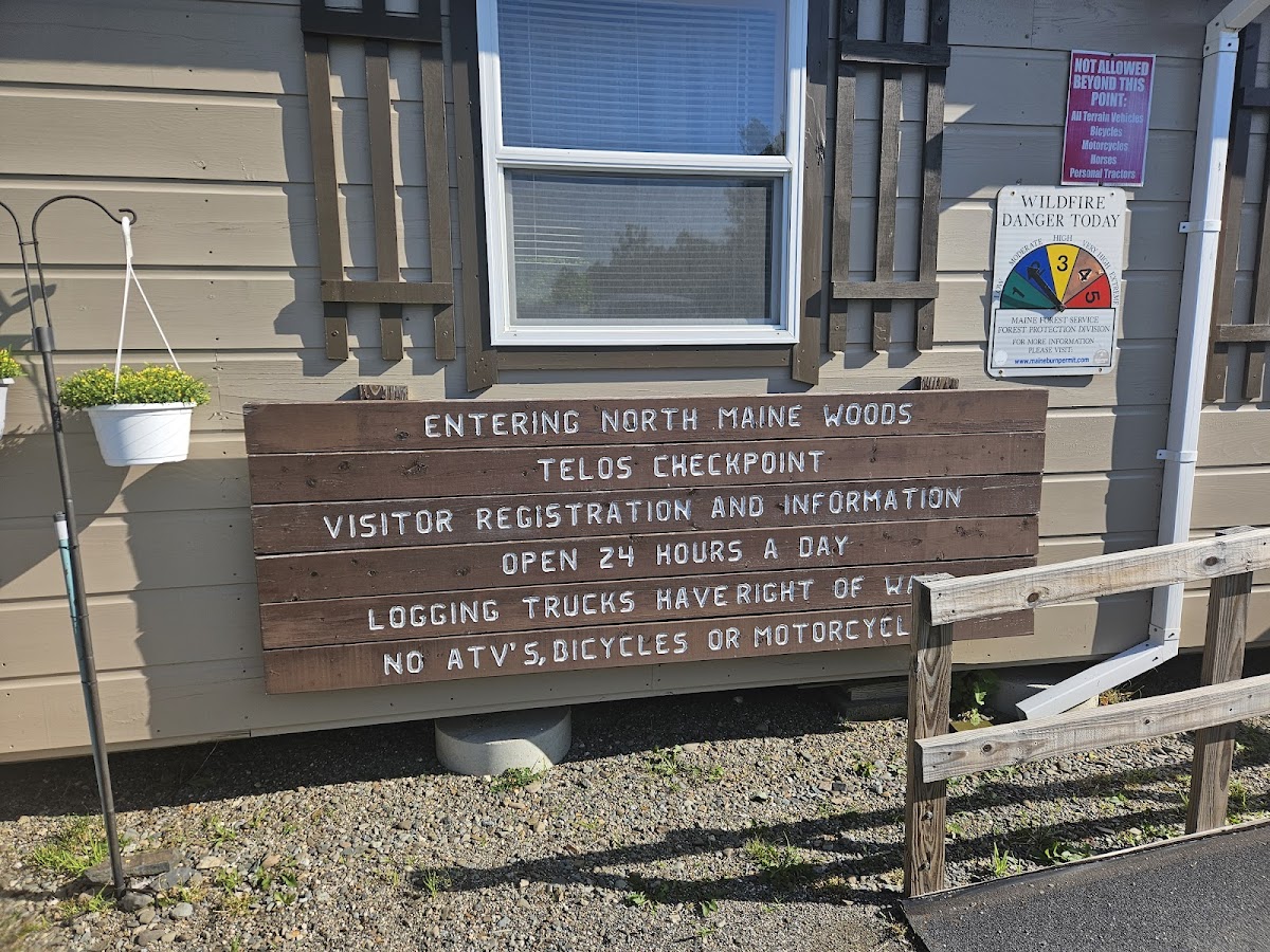
Checkpoints and Access
Entry to the North Maine Woods is through staffed checkpoints — the roads are gated and checkpoints are the only legal entry points. Major checkpoints include Telos Gate (commonly used for Allagash Wilderness Waterway access, reached from Millinocket via the Golden Road), Harveys Gate (from Patten), Churchill Dam Gate (middle Allagash area), and St. Francis Gate (from the St. John Valley). The Golden Road — the main east-west logging road connecting Millinocket to Moosehead Lake — is the primary access route for most visitors.
Fees
Fees are charged per person per day for both day use and camping — paid at the checkpoint at entry. Fees differ for Maine residents and non-residents. Children under approximately 15 are admitted free or at reduced rates. Cash is preferred at most checkpoints. Current fees change annually — always check northmainewoods.org for current rates before your trip. The NMW fee covers road access and designated camping areas but does not cover fishing licenses, hunting licenses, or Allagash Wilderness Waterway camping fees (charged separately).
Road Conditions and Vehicle Requirements
High-clearance vehicles are strongly recommended. Road quality deteriorates the deeper you go into the territory. Mud season (April-May): Many roads closed or severely restricted — check with NMW before a spring visit. Logging truck traffic: NMW roads are shared with large logging trucks that have the right of way. Drive at safe speeds, stay to your side, and yield to trucks. Carry a full-size spare tire — flat tires are common and roadside assistance does not exist in the NMW.
Cell Service and Communication
Cell service is essentially nonexistent throughout most of the North Maine Woods. Before entering: download offline maps (Gaia GPS or OnX Maps work well), file a trip plan with someone who knows your expected return date, and consider a personal locator beacon (PLB) or satellite communicator (Garmin inReach) for emergencies. The checkpoint staff have current, local knowledge about road conditions — take advantage of this before heading in.
Camping in the North Maine Woods
The NMW maintains designated primitive campsites throughout the territory — remote sites on lakes, ponds, and rivers with basic amenities: fire ring, privy, and cleared tent pads. No hookups, no potable water, no camp stores. Most sites are first-come, first-served with no reservations. Allagash Wilderness Waterway campsites within the AWW corridor require separate registration through Maine Bureau of Parks and Lands.
What to Do in the North Maine Woods
Fishing: Hundreds of remote lakes, ponds, and streams holding wild brook trout, landlocked salmon, lake trout, and smallmouth bass. See our Maine fishing license guide and fly fishing in Maine guide.
Moose watching: One of the highest moose densities in North America. Dawn and dusk drives on logging roads through bog and wetland areas produce regular sightings. See our Maine moose watching guide.
Allagash Wilderness Waterway: The 92-mile AWW canoe route through the heart of the NMW is one of the finest wilderness paddling routes in the eastern United States.
Planning Resources
- northmainewoods.org — current fees, checkpoint locations, road conditions, and camping information
- Maine Atlas and Gazetteer (DeLorme) — essential paper map for NMW navigation, available at outfitters statewide
- Gaia GPS / OnX Maps — downloadable offline maps that work without cell service
Plan Your Trip
Ready to explore the North Maine Woods? Start at northmainewoods.org for current fees and checkpoint information. For nearby activities and lodging, see our guides to Things to Do at Moosehead Lake, Moose Watching in Greenville Maine, Katahdin Woods and Waters National Monument, and our Greenville Maine seaplane tours guide.
About MaineGuide.com: MaineGuide.com has been helping visitors plan their Maine trips since 1995 — making us one of the longest-running and most comprehensive Maine travel resources on the web. Our guides are built on decades of firsthand Maine knowledge, local expertise, and a genuine love for the state.
📌 Paddling into the North Maine Woods? Read our complete Moose River Bow Trip guide — Maine’s finest canoe loop through Attean Pond and the Moose River wilderness.