The Bold Coast is one of the finest and least known hiking destinations in the eastern United States. Stretching along the Washington County coastline between Cutler and Lubec, this section of the Maine coast is characterized by dramatic cliffs dropping directly into the Gulf of Maine, exposed headlands battered by open ocean swells, jack pine forest growing from bare granite, and coastal heath that turns crimson in late summer. There are no tourist facilities here, no entrance fees, and on most days, almost no other hikers.
The Bold Coast Trail — Cutler Coast Public Reserved Land
The centerpiece of Bold Coast hiking is the trail system within the Cutler Coast Public Reserved Land — 12,234 acres of coastal wildland owned by the State of Maine, accessible from a trailhead on Route 191 between Cutler and West Lubec.
The Coastal Trail Loop (approximately 9.4 miles) — The full loop is the definitive Bold Coast experience. The route heads out through boreal forest before reaching the coast at Fairy Head, where the trail emerges onto open headlands above vertical cliffs dropping 100 feet or more to the ocean below. Three primitive backcountry campsites are available along the coastal section. The full loop takes 5-7 hours for most hikers.
Short Coastal Walk (approximately 2 miles) — For those without a full day, a shorter out-and-back walk accesses the first headland viewpoints without committing to the full loop. Even this short section delivers cliff-top views that make the drive worthwhile.
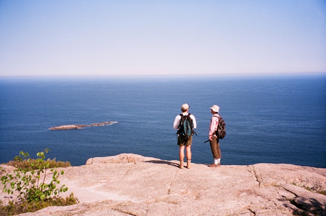
Fairy Head
Fairy Head is the first major coastal promontory on the Bold Coast Trail — a dramatic headland where the trail breaks out of the forest onto open cliff tops above the Gulf of Maine. The views take in the open ocean, offshore ledges where seabirds nest, and on clear days, Grand Manan Island in New Brunswick to the east. This is an excellent seabird watching location — common murres, razorbills, black guillemots, and Atlantic puffins are all present in the offshore waters during summer.
Great Wass Island Preserve
About 20 miles southwest of the Cutler Coast trailhead, the Great Wass Island Preserve protects 1,579 acres of coastal wildland on Great Wass Island, accessible by bridge from Beals Island near Jonesport. Owned and managed by The Nature Conservancy.
The Mud Hole Trail (approximately 5 miles round trip) — Heads south through jack pine forest and coastal heath to the southern tip of the island, where open ledges and cobble beaches provide dramatic views across the Gulf of Maine.
The Little Cape Point Trail (approximately 4 miles round trip) — Reaches the eastern shore of Great Wass Island with views toward the offshore islands of the Jonesport archipelago. Great Wass Island is exceptional for seabird watching.
Quoddy Head State Park
West Quoddy Head State Park in Lubec protects the easternmost point of land in the United States, marked by the iconic red-and-white striped West Quoddy Head Lighthouse. The park offers a network of coastal hiking trails with spectacular Bay of Fundy views.
The Coastal Trail (approximately 3 miles round trip) — Heads north from the lighthouse along the Bay of Fundy shoreline, passing through coastal forest and emerging onto open headlands. The trail accesses Gulliver’s Hole — a sea cave carved into the headland — and Carrying Place Cove, a dramatic cobble beach.
The Bog Trail (approximately 1.5 miles) — A boardwalk loop through a coastal raised peat bog featuring carnivorous sundews, bog laurel, and other specialized bog vegetation.
Wildlife on the Bold Coast
Seabirds: Common murre, razorbill, black guillemot, Atlantic puffin, and northern gannet are regularly observed from the cliff-top trails. Bring a spotting scope or quality binoculars.
Bald eagles: Washington County has one of the highest concentrations of nesting bald eagles in the eastern United States — expect to see multiple eagles on any Bold Coast hiking day.
Seals: Harbor and gray seals haul out on offshore ledges visible from the cliff-top trails throughout the season.
Whales: Minke and finback whales are occasionally visible from the higher headlands during summer, particularly in calm early morning conditions.
Planning Your Bold Coast Hike
Getting there: The Cutler Coast trailhead is on Route 191 between West Lubec and Cutler — 30 minutes from Lubec and about 45 minutes from Eastport. Great Wass Island is accessible from Jonesport via the Beals Island bridge. West Quoddy Head State Park is in Lubec.
- Weather: Bring a waterproof layer and wind protection — the cliff-top trails are fully exposed and conditions change rapidly
- Bugs: Black flies are serious from mid-May through mid-June — coastal breeze helps after that
- Water: No water sources on trail — carry a minimum of 2 liters per person
- Cell service: Essentially nonexistent — download trail maps offline before you go
- Dogs: Allowed on leash on all three trail systems listed here
Where to Stay
Lubec and Eastport are the most practical base camps for Bold Coast hiking. Browse our Eastport city guide for lodging options. For the full Downeast experience, see our Downeast Maine Road Trip Itinerary which includes the Bold Coast as a key stop.
Plan Your Trip
Ready to hike the Bold Coast? Browse our Eastport city guide and Downeast Maine guide for trip planning resources. For more Maine hiking, see our Maine hiking guide. Combining hiking with wildlife watching? Read our Maine moose watching guide for tips on finding Maine’s iconic wildlife.
MaineGuide.com has been helping visitors plan their Maine trips since 1995.